

I’ve visited a bunch of Olmsted parks. Each is different and incredible in ways I never suspect, despite pouring over the plans and examining all available photography before hand. I know many people have visited more of his parks than I have, but I doubt anyone has been to them all.
For one thing, I don’t think anyone’s looked in a long time to see what still exists. A “Master List of the Design Projects of the Olmsted Firm” has been compiled, and it includes every project initiated. But not which were completed and what their current status is. (In a future post, I’ll include the list I’m working with, and I’ll welcome additions.) The major parks are famous, but he designed dozens over the course of his career and many people can only name his first.
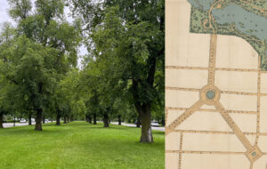
So, my goal to document all of Olmsted’s parks hopes to serve two goals: a visual guide anyone can access online to appreciate Olmsted’s work, and a new inventory of existing parks and their condition. I’m inspired by the image cataloging practices of the Olmsted firms, themselves.
In Fairsted, Olmsted’s home and offices in Brookline, MA, there is a room entirely devoted to documenting the landscapes the Olmsted firm created. To help the designers in Massachusetts understand how a site looked like from ground level, photographs taken there were assembled into tomes illustrating the property in all stages of its development. (Many of these volumes have been digitized by the Olmsted National Historic Site and are available online. See the link at the end of the post.)

In 1980, the Olmsted firm in Brookline closed and the National Park Service adopted the property as an historic site. While they do an excellent job maintaining the archive of drawings and images, the collection process had stopped years before the firm closed shop. Individual parks have gone to great lengths to document and preserve their landscapes, but many parks are still under threat from development, and others are known only to a handful of vigilant local volunteers. As far as I know, there hasn’t been any kind of systematic effort to take an inventory of all existing parks, capturing what they look like now. That is my goal with my panoramic tours, and like the parks themselves, I want to make the results of my work accessible to everyone.
If we are to protect these irreplaceable works of art, we need to identify them and document how they look before global warming and aggressive funding cuts alter them. Without being able to see the scope of what Olmsted and his sons built, it’s impossible to appreciate fully his contribution to the quality of life in America.

